 11-12-08, 09:13 PM
|
#1 |
|
Administrator

Join Date: Jul 2005
Posts: 651
|
NEW BassFishin.Com Production Video
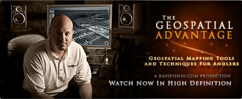 The Geospatial Advantage Geospatial Mapping Tools and Techniques For Anglers In addition, we have made a page listing all the resources detailed in the Production Video. You may view it at: http://www.bassfishin.com/mapvideo1/
__________________
Kevin Scarselli |

|
|
11-13-08, 12:21 PM
|
#2 |
|
BassFishin.Com Super Veteran

Join Date: Jul 2007
Posts: 1,134
|
I have used the software and applications you mentioned in the past, but never at the level explained in your video. The features you showed in that video probably helped my mapping of new water/ potential hot spots better than anything i've ever seen before.
Thanks Doc |
|
|
|
11-13-08, 01:04 PM
|
#3 |
|
BassFishin.Com Super Veteran

Join Date: Jul 2005
Location: Brighton, MI
Posts: 2,414
|
Same thing with me, I stayed up way too late last night getting a lot more information from the resources that I have been using previously not to their full potential. Thanks!
|
|
|
|
11-13-08, 03:24 PM
|
#4 |
|
BassFishin.Com Veteran Member
Join Date: Jul 2007
Location: South Arkansas
Posts: 937
|
just what i need...more of an excuse to sit in front of the computer!!!!! thanks kev.
|
|
|
|
11-13-08, 06:00 PM
|
#5 |
|
BassFishin.Com Super Veteran

Join Date: Mar 2008
Location: Jonesville, Indiana
Posts: 3,597
|
I know what I'm gonna be doing this winter.
Nice job Kevin! 
|
|
|
|
11-15-08, 12:03 PM
|
#6 |
|
BassFishin.Com Active Member
Join Date: Jul 2008
Posts: 180
|
Correct me if I'm wrong, but I don't really follow the advantage presented for using Google Earth. Especially as the video shows trying to indentify inflows/outflows, clear water, etc...The reason being, the Google Earth images can be a year old. I took a look at our lake, and the images are clearly old and wouldn't be of the use identified in the video.
|
|
|
|
11-15-08, 01:43 PM
|
#7 |
|
BassFishin.Com Member
Join Date: Nov 2008
Posts: 1
|
First off I want to say thank you so much. The video is so informational. I have a questions though. I believe in the video you were using a Mac. I too have a brand new Mac and can't seem to find how to run World Wind on it. Any info on where to download or how to run it on a Mac would be greatly appreciated.
Thanks. |
|
|
|
11-15-08, 06:44 PM
|
#8 |
|
BassFishin.Com Premier Elite

Join Date: Jan 2004
Location: denton nc
Posts: 13,441
|
if you have a standard gps take it with you while fishing 90% of all gps systems have elevation readings. the main lake will be a certain elevation while water flows DOWN hill. anything with a higher elevation will be upstream..
do ya think the water is flat or something?? it aint trust me.. zooker
__________________
the godfather.. aml in remission since 7-20-09 |
|
|
|
11-15-08, 08:21 PM
|
#9 |
|
BassFishin.Com Premier Elite

Join Date: Mar 2005
Posts: 8,655
|
so when you see a lake and look at the tide, is google earth in real time?
The ones I've seen are dated photo's of the satalite pic...just wondering..anyone know? |
|
|
|
11-15-08, 09:07 PM
|
#10 | ||
|
Administrator
Join Date: Jul 2005
Posts: 651
|
Quote:
Quote:
Of course tidal flow and bottom contour stays pretty consistent, even over years, so you can extrapolate based on what you see inside of Earth or World Wind. Google Earth displays the date the imagery was captured on at the very bottom of the application.
__________________
Kevin Scarselli |
||
|
|
|
11-15-08, 09:32 PM
|
#11 |
|
BassFishin.Com Premier Elite
Join Date: Mar 2005
Posts: 8,655
|
Thanks! *figured you'd had a tidal explanation on file* ROfL
|
|
|
|
11-16-08, 11:52 AM
|
#12 |
|
BassFishin.Com Active Member

Join Date: Sep 2007
Location: Swartz Creek, Michigan
Posts: 163
  |
My sincere thanks for "Dumbing it down" a bit for the 2 or 3 of us that aren't real computer savvy!!!! I wore out the pause button while taking notes...lol. Keep the videos coming, water is getting hard as we speak. My wife walks in asking what I am doing, tell her watching fishing vids. She says, well, better than porn I guess. I told her it IS porn to me. Great stuff

|
|
|
|
11-20-08, 12:06 AM
|
#13 |
|
BassFishin.Com Premier Elite

Join Date: Dec 2001
Location: Huntsville, Al
Posts: 7,466
|
It was a real good video. Didnt even know world wind existed. That sun angle tip has the potential to be huge if you think about it. I'm not certain how accurate it is, but the more they work on it the better it will get for predicting shade and sun areas.
__________________
Selling live waterdogs for less since 2005. |
|
|
|
12-03-08, 07:26 PM
|
#14 |
|
BassFishin.Com Veteran Member

Join Date: Nov 2008
Location: Suffolk County, NY
Posts: 542
|
I sincerely doubt that we will ever get real time satellite imagery from Google. Just can't see the gov't allowing it for security reasons.
I've been using Google for some time, and I've always checked the imagery of my home, which is still several years old at best. This makes using Google nearly useless for checking out new bodies of water as far a laydowns are concerned. However, I do use Google for getting familiar with a new body of water. |
|
|
 |
|
Disclosure / Disclaimer
Before acting on the content posted, you should know that BassFishin.Com may benefit financially and otherwise from content, advertising, links or otherwise from anything you click on, read, or look at on our website. Click here to read our Disclosure Policy and Disclaimer. |
| Currently Active Users Viewing This Thread: 1 (0 members and 1 guests) | |
|
|


 Linear Mode

